The Cloud-Bound Summit: How Saba’s Mount Scenery Holds the Soul of the Unspoiled Dutch Caribbean (2026)
In 1640, a small band of Dutch settlers, fleeing the chaos of Europe’s religious wars, stumbled upon a volcanic cone rising sheer from the Caribbean. They named it Saba, from the Arawak word for “rock.” For three centuries, the island remained nearly inaccessible—a place where mail was hauled up a hand-cut stone staircase of 862 steps, known as the Ladder. When the first concrete road was blasted into the mountain in 1958, locals lined up to touch the black asphalt, a moment that forever changed how you will experience the cloud-shrouded slopes of Mount Scenery.
The Story Behind Saba’s Mount Scenery, Netherlands
Mount Scenery is not just the highest point in the Kingdom of the Netherlands—it is the dormant heart of a volcano that last stirred around 1640, the same year the first permanent European settlers arrived. Indigenous Taíno and Carib peoples had long called Saba a sacred place, but they left no permanent structures; the steep terrain saw to that. Dutch, English, and Scottish planters, desperate for arable land, carved terraces into the mountain’s flank, growing sugarcane, coffee, and indigo. By the 1800s, these plantations had collapsed, and Saba’s economy shifted to fishing and the legendary lace-making that still earns women in Windwardside a living today.
The mountain itself—887 meters (2,910 feet) above the sea—is a nature lover’s paradox. You will find a tropical elfin forest at its peak, where ferns, bromeliads, and dwarf trees are draped in mist almost year-round. The summit was first properly surveyed in 1865 by a British naval officer, who noted that from the top you could see six islands on a clear day. But locals had been climbing the volcano for centuries, hunting wild goats and gathering medicinal herbs. In 1997, the Saba Conservation Foundation established a formal trail, now the most popular hike on the island, and in 2010, Mount Scenery was declared a protected national park. Travelers often discover that this climb offers more than a view—it offers a pilgrimage into Saba’s soul.
Today, the volcano rumbles only in legend: an old Saban tale warns that if you take a stone from the summit, the mountain will bring bad luck to your home. Most visitors heed that warning, choosing instead to leave only footprints and take only photographs of the breathtaking, cloud-carpeted panorama.
Neighborhood by Neighborhood
The Bottom
The Bottom is Saba’s capital, but don’t expect a bustling downtown. You will find a tidy village of pastel cottages with white roofs, clinging to a crater-shaped valley at the base of Mount Scenery’s western flank. The main street, the aptly named Ladder Path, is where the old stone staircase from the harbor meets the road. Here, the Saba University School of Medicine gives the town a youthful buzz; students fill the cafés at noon, and the Saba Artisans Foundation shop on Fort Bay Road sells the island’s famous lace—delicate, hand-stitched linen that takes weeks to create. Locals recommend stopping at the Saba Heritage Center in an old government building to see the vintage maps and a model of the first airstrip. The Bottom’s quiet charm is its greatest asset: you will hear the wind rustling banana leaves and the occasional bleat of goats, but little else. It’s the kind of place where you can sit on a bench and watch a day slip by, just as the island’s 1,900 residents do.
Windwardside
If The Bottom is Saba’s heart, Windwardside is its bustling, tourist-friendly face. Nestled on a ridge about 500 meters up the volcano, this village is the launch point for your Mount Scenery climb. The main drag, Sandy Cruz Road, is lined with inns, gift shops, and restaurants like the cozy Scout’s Place, where you can get a cold Saba Spice rum punch before or after the hike. Windwardside is where travelers discover the island’s surprising elevation: from the veranda of the Gate House hotel, you can look straight out to the Caribbean, feeling like you’re on a cloud. The Harry L. Johnson Museum, a restored 19th-century sea captain’s home, offers a glimpse into Saba’s seafaring past—the captain sailed schooners from here to New York, and his bedroom still has a telescope pointed out to sea. You will also find the trailhead for the Mount Scenery hike just behind the museum; a sign reads “1,064 steps to the top” in cheerful red paint. Windwardside is where you’ll spend most of your evenings—sitting on a hillside terrace, listening to the tree frogs sing, and watching the stars punch through the tropical dark.
Hell’s Gate
Don’t let the name fool you. Hell’s Gate is the smallest and most eccentric of Saba’s four villages. You will reach it by climbing a series of hairpin turns on the island’s only road—a marvel of engineering that wasn’t completed until 1963. The village sits at the base of a steep spur of the volcano, overlooking the wild east coast where waves crash against black cliffs. Only about 80 people live here, and they are famously friendly; you might get invited into a home to see a scrapbook of old Saba photographs. The real draw is the trail that starts here—the Ladder, the original limestone staircase that connected the village to the harbor before the road was built. Climbing these 862 steps is a rite of passage for fit travelers; from the top, you’ll see the whole curve of Saba’s coast. Hell’s Gate also has a tiny chapel, the Church of Our Lady of the Rosary, which dates to 1840 and is often decorated with fresh frangipani. If you want to feel like an explorer in a forgotten corner of the world, this is your neighborhood.
The Local Table: What Sabans Actually Eat

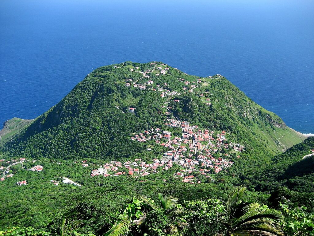
This dormant volcano on the center of the island hosts a cloud forest on it…, Saba’s Mount Scenery, Netherlands
Sabans are descendants of sailors, farmers, and fishermen, and their cuisine is a rugged, no-nonsense celebration of what grows and swims here. Forget fancy fusion—your best bet is a plate of “goat water” (a rich, tomato-based goat stew), served with rice and beans at the Lollipop Café in Windwardside for about $12 US. Seafood dominates: lobster, red snapper, and conch are caught within a kilometer of the shore, and you’ll find them grilled or fried with a dash of Old Bay and lime. The real signature dish, however, is Saba Spice, a potent rum-based liqueur infused with cinnamon, cloves, and local bush tea. Locals recommend buying a bottle directly from the Saba Spice factory at the bottom of Mount Scenery’s trail—it’s a sticky, sweet-sipping rum that cuts through the mountain mist.
But the heart of Saba’s food culture is the backyard garden. Nearly every home has a patch of taro, yams, plantains, and pigeon peas scratching a living out of volcanic soil. On Saturday mornings, from 7 a.m., the Windwardside market (right by the Harry L. Johnson Museum) becomes a gathering spot where farmers sell their just-picked produce and women hand out slices of “johnnycake”—a fried bread that’s the island’s comfort food. Travelers often discover that the best meal is a simple one: a conch fritter from a roadside stand, a cup of bush tea (made from local lemongrass or soursop), and a slice of fresh pumpkin pie from the Saba Bakery on Sandy Cruz Road. Savvy visitors book dinner at the eco-resort Juliana’s, where chef Lisa Quik uses produce plucked from the garden that afternoon—her “Mountain View” menu changes daily, but you’ll always find something that tastes of the volcano’s earth.
One dish you must seek out is the “funji” (pronounced “foon-ji”), a cornmeal dumpling that resembles polenta, served with an okra-and-saltfish sauce. It’s Saba’s soul food, and the best version is found at the roadside stall run by Miss Dora in The Bottom (open Thursday through Sunday, noon to 6 p.m.). She’ll serve it on a banana leaf and charge you $5—a meal that tastes like the whole island in a bite.
Art, Music & Nightlife
Saba’s creative spirit is woven, not painted. The island is world-famous for its hand-stitched Saba lace, a craft brought by 19th-century Scottish nuns that has been passed down for generations. You can see women stitching on porches in Windwardside, their needles dancing faster than the trade winds. The Saba Lace and Artisans Shop in The Bottom is the place to buy a doily or tablecloth—each piece takes weeks to complete, and prices range from $40 for a small handkerchief to $300 for a masterwork. In June, the island hosts the Saba Day celebrations (around the first weekend of December, not June—July 6 is Saba Day, actually) with crafts fairs, music, and traditional dancing. But nightlife is modest: a few bars like the “Eco Bar” at the Gate House hotel host live steelpan and folk music on Friday evenings, and the “Ishmael’s Bar” in Windwardside has a karaoke night on Saturdays that can get raucous. If you want to paint or photograph, the mountain itself is your studio—the light at dawn over the summit is an artist’s dream. The local art gallery, “Art from the Heart,” in Windwardside sells watercolors and photographs of the island by resident artists; owner Jenna Safford will happily show you her studio for free, and you can buy a print for $50.
Music on Saba is a blend of Caribbean calypso, reggae, and Dutch folk—a strange but lovable mix. The annual Saba Day festival on December 5–6 features a parade, a “King of the Mountain” race up the Ladder, and a street party in The Bottom with DJs blasting soca and dancehall. For a quieter evening, visit the “Scout’s Place” bar on a Tuesday, when local guitarist “Uncle” Rupert plays old sea shanties on the back porch, often joined by a spontaneous chorus of tourists. You’ll leave humming a tune that sticks in your head for days.
Practical Guide

Body of water beside green trees and wind mills, Saba’s Mount Scenery, Netherlands
- Getting There: Fly from Sint Maarten (SXM) on Winair into Saba’s Juancho E. Yrausquin Airport (SAB)—a 20-minute flight that lands on one of the world’s shortest runways (just 400 m). Book at Skyscanner; round-trip flights from SXM cost $120–$180. No direct international flights.
- Getting Around: Saba has no rental car agencies that your credit card will recognize; locals recommend arranging a taxi from the airport (approximately $20 to Windwardside). The island’s only road is a narrow, winding affair, so walking and hiking are your best bets. A public minibus runs between villages twice daily ($2 per ride). For the Mount Scenery hike, you don’t need a car—the trailhead is a 10-minute walk from the center of Windwardside.
- Where to Stay: For budget, stay at the “Eco Lodge Saba” in The Bottom (dorm beds from $40, private rooms from $90). Mid-range: “Scout’s Place” in Windwardside (doubles from $120, includes breakfast). Splurge on the “Gate House” hotel (doubles from $250, with panoramic views). Check Booking.com for last-minute deals.
- Best Time: December through April is the dry season, with clear skies for hiking and fewer mosquitos. Temperatures hover around 24°C (75°F) at sea level and 18°C (64°F) on the summit. May–October is wetter but cheaper; expect afternoon showers that clear to brilliant sun.
- Budget: You can get by on $100–$150 US per day if you eat locally and stay in a guesthouse. With a guided hike, nicer meals, and a mid-range hotel, budget $200–$250 per day. There are no ATMs on the island, so bring enough cash for your stay.
What Surprises First-Time Visitors
Most travelers arrive expecting a Caribbean island with white-sand beaches. Saba has none. Your first surprise will be the sheer verticality of the place: you’ll step off the plane onto a strip of asphalt that ends at a sheer cliff, and from there, the road climbs so steeply that cars have to back up to pass each other on hairpin turns. But the lack of beaches is quickly forgotten when you stand on the mountainside and look down at the turquoise sea from a height that makes you dizzy.
Another shock is the language. Everyone speaks English—fluently, with a lilting Caribbean accent that sounds unlike the Dutch you might expect. Saba is a special municipality of the Netherlands, but locals identify as Sabans first. You’ll be greeted with a warm, unhurried friendliness that feels from a slower century. Shopkeepers will close their stores for lunch, and taxi drivers will stop to help a goat cross the road. Savvy visitors learn to adjust their pace: nothing happens fast here, and that’s the point.
Finally, the silence. At night on Mount Scenery’s slopes, you can hear a leaf drop. There are no streetlights, no traffic hum—just the rustle of tree frogs and the distant roar of the surf. Travelers often discover that this quiet is more luxurious than any five-star hotel. It’s the reason people return year after year.
Your Saba’s Mount Scenery, Netherlands Questions

Brown and white house near lake during daytime, Saba’s Mount Scenery, Netherlands
How difficult is the Mount Scenery hike, and do I need a guide?
The climb is about 1.5 miles round-trip (2.4 km) with 1,064 steps carved into the volcanic rock. It takes 45 minutes to an hour up for a fit person, and 30–40 minutes down. The stairs are uneven and often wet, so sturdy shoes are essential. You don’t need a guide—the trail is well marked with yellow arrows—but many travelers prefer a local guide for $40–50 per person to learn about the rainforest ecology and hear Saban folklore. Book a guide through the Saba Conservation Foundation at the trailhead; they offer daily departures at 6:30 a.m. and 1 p.m. The early morning hike gives you the best chance of a clear summit view before clouds roll in by 9 a.m.
What is the weather like on the summit, and what should I pack?
Expect cool, misty conditions even when the coast is sunny. Temperatures at the peak can drop to 16°C (60°F) with wind chill. Pack a light fleece or windbreaker, long pants, and a waterproof layer. The sun can be intense on the lower sections, so wear a hat and sunscreen. You’ll also want to carry at least 1 liter of water per person—there’s no source on the trail. Many hikers forget a flashlight for early ascents;